
![]()
![]() New Omnidirectional Mapping Drone Enhances Monitoring of Vital Seaweed Beds for Carbon Deposits and Ecosystem Health
New Omnidirectional Mapping Drone Enhances Monitoring of Vital Seaweed Beds for Carbon Deposits and Ecosystem Health
This article published in collaboration with JUIDA, the Japan UAS Industrial Development Association.
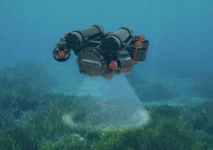 Tokyo-based underwater infrastructure provider INFLUX, in collaboration with Nagasaki University’s Marine Future Innovation Institute and the Graduate School of Engineering, recently announced that they had developed the Aquaremona mapping drone to aid in accurate surveys of vital seaweed beds. Designed for maximum resistance to the powerful local tidal currents, the Aquaremona will monitor these previously unexplored vulnerable ecosystems for carbon deposits and other important biomarkers.
Equipped with eight separate sensor clusters, the Aquaremona is completely omnidirectional and features a swappable battery system to maximize range. It features two cameras and a sonar function to determine the complex underwater topography in the area. Utilizing optical flow technology on its dual camera feed allows it to maintain a stable position, which is difficult to do manually in this complex and unique operating environment.
On a simulated seaweed bed in Shimabara Bay, Shimabara City, Nagasaki Prefecture, the technology was showcased with a grid of 1m x 1m spaced tubing. The Aquaremora quickly created a detailed 3D model, mapping the region out. The detailed height information gathered on the plants allows the Aquaremora to quickly assess the seaweed bed’s carbon dioxide-absorbing abilities, an important next step in the fight against climate change. Coastal denudation and warming waters have weakened Japan’s seaweed beds, which become an important processor of “blue carbon”, or carbon dioxide stored in water. INFLUX hopes to begin commercializing so-called “blue” carbon credits related to these seaweed beds in the near future.
Partially as a result of climate change, better ways of understanding underwater biomes have become more important over the last couple of years. A similar project by the University of Florida and Aurigo Software, called Bathyscope, uses a different model with a “home-base” main craft alongside smaller units for mapping depth. It is already being used in the United States for infrastructure inspection and similar biome management.
Other offshore operations by INFLUX include offshore power generation inspection. More information on their business, alongside quotes, is available here.
Read more:


