
Sign up for daily news updates from CleanTechnica on email. Or follow us on Google News!
Wind Forecast Improvement Project will Monitor Weather, Ocean, and Wildlife Data Near Active and Proposed Offshore Wind Farms off the East Coast
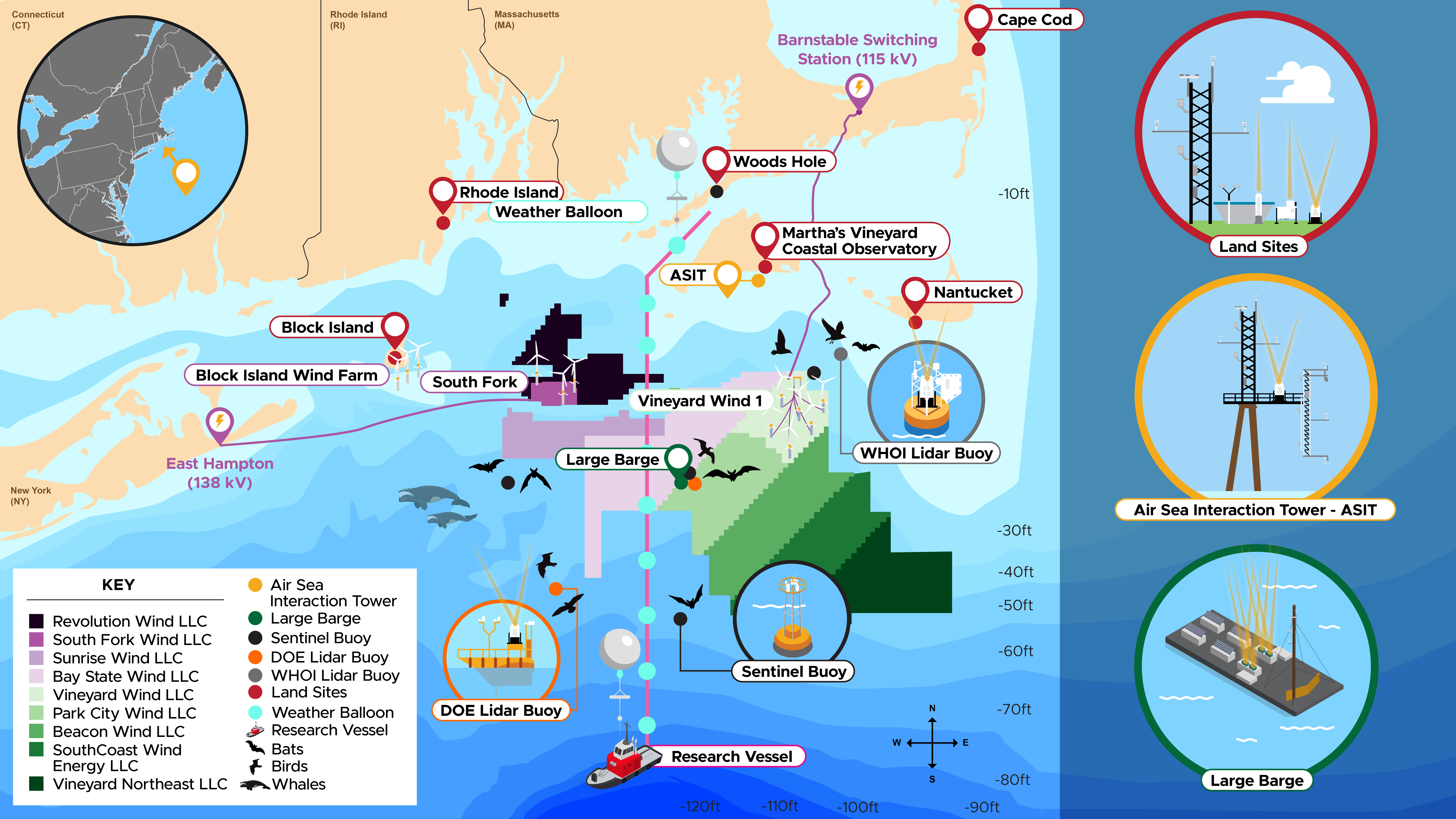
Today, the U.S. Department of Energy (DOE) and the National Oceanic and Atmospheric Administration (NOAA) launched an 18-month initiative to gather extensive weather, ocean, and wildlife data near the sites of active offshore wind farms and lease areas off the coast of the Northeast United States. This effort, which is part of the third phase of the Wind Forecast Improvement Project (WFIP3), seeks to gather high-quality data to improve the design and operation of offshore wind turbines and wind farms. The collected data will be publicly available and used to inform responsible offshore wind siting, weather forecasting, and grid integration, as well as support advancements in weather and wind plant modeling.
“Our oceans are the next frontier for clean energy deployment,” said Alejandro Moreno, Associate Principal Deputy Assistant Secretary for Energy Efficiency and Renewable Energy. “Understanding the offshore environment better is a “grand challenge” that DOE and its partners are addressing to ensure that offshore wind can not only operate efficiently and sustainably, but also contribute to grid reliability in the energy system of the future.”
Understanding wind and weather patterns is crucial for the efficient operation of wind farms and ensuring reliable operation of the electricity grid. Offshore environments add an additional layer of complexity due to interactions between the atmosphere and the ocean. Accurate forecasts are essential for maximizing wind plant output and efficiently managing wind farms.
“The major goal of WFIP3 is to characterize the wind energy environment and what processes impact the wind speeds at hub-height,” said Dave Turner, manager of NOAA’s Atmospheric Science for Renewable Energy Program. “We want to use these insights to improve NOAA’s operational weather prediction models, which often serve as the foundational forecasts for the energy community in their daily management of their wind plants.”
Over the last three months, researchers have deployed state-of-the-art remote sensing instruments, offshore buoys, and towers at various locations off the coasts of Massachusetts, Rhode Island, and Long Island—home to Vineyard Wind, Block Island Wind Farm, South Fork Wind Farm, and seven other lease areas. Starting today, instruments will collect real-time data on a wide range of weather-related variables over the next 18 months.
To ensure the coexistence of offshore wind deployment with ecosystems and other ocean users, WFIP3 platforms are also being used to monitor wildlife, including whales, birds, and bats. Wildlife data, collected alongside weather and ocean data, will improve our understanding of movement patterns and provide insight into the potential effects of offshore wind construction on wildlife in the region.

WFIP3 is funded by DOE and NOAA and led by the Pacific Northwest National Laboratory and Woods Hole Oceanographic Institution, with over 15 partners including national laboratories, universities, industry, and cooperation from local governments. The wildlife monitoring is a project of Duke University with funding from DOE and the Bureau of Ocean Energy Management.
“The diversity of partners collaborating on WFIP3 speaks to the importance of this work to virtually every sector of society,” said Anthony Kirincich, senior scientist at the Woods Hole Oceanographic Institution and lead principal investigator of WFIP3. “We are excited to be working with our federal partners, as well as the Massachusetts Clean Energy Center, in pursuit of the Department of Energy’s goals to advance science, lower the cost of energy, and protect wildlife in offshore wind energy areas.”

This third phase of the Wind Forecast Improvement Project builds on the success of the first and second phases, which collected data to improve the accuracy of short-term land-based wind forecasts. NOAA has been a partner in all three phases of WFIP, and has used data from the first two phases to update and improve widely-used operational weather models, saving utilities and customers millions of dollars.
Upon completion of the data collection campaign, the monitoring platforms and instruments will be removed from the ocean, and the study’s data and results will be published and used to improve the accuracy of weather forecasts for the region.
Learn more about DOE’s efforts to characterize wind resources and advance offshore wind and sign up for the Wind Energy Technologies Office’s newsletter.
Courtesy of U.S. Department of Energy.
Have a tip for CleanTechnica? Want to advertise? Want to suggest a guest for our CleanTech Talk podcast? Contact us here.
Latest CleanTechnica TV Video
I don’t like paywalls. You don’t like paywalls. Who likes paywalls? Here at CleanTechnica, we implemented a limited paywall for a while, but it always felt wrong — and it was always tough to decide what we should put behind there. In theory, your most exclusive and best content goes behind a paywall. But then fewer people read it!! So, we’ve decided to completely nix paywalls here at CleanTechnica. But…
Thank you!
CleanTechnica uses affiliate links. See our policy here.


