
 Simplifying Data Collection and Enhancing Collaboration with User-Friendly Features for Surveyors and Pilots
by DRONELIFE Staff Writer Ian J. McNabb
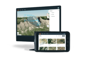
Swiss developer Wingtra, a leader in the VTOL mapping space, recently announced the unveiling of its new WingtraCLOUD software, designed to “revolutionize the way customers expand their drone programs and operations.” WingtraCLOUD promises to simplify data collection and streamline the onboarding process for both surveyors and pilots, providing vital drone data planning and collaboration abilities to its customers.
 With a completely new, user-friendly interface and flight planning experience, the new software includes time-saving features like site-based file organization, advanced 3D planning, full site coordination, and improved connectivity via cloud storage syncing. This all-in-one solution makes business operations more streamlined for a wide range of organizations, allowing them to optimize their time and money. Since different stakeholders have shared access to the information in the app, WingtraCLOUD promises to increase collaboration and ward off costly miscommunications.
Key Features
According to Wingtra, the key features of WingtraCLOUD include:
- Avoiding version control issues by allowing any permitted stakeholder to access any project from anywhere, anytime
- Organizing flights and files intuitively according to projects, enabling quick access to the latest insights with one click
- Empowering even junior pilots to fly with confidence and precision using direct import of background maps and simple 3D flight features
- Ensuring no re-flights or surprises in data through preflight accuracy checks and intuitive elevation graphs with color-coded GSD and AGL height indicators
- Fly with confidence knowing that your base station and checkpoints are set up thanks to a ground-setup pre-flight assessment feature
- Optimizing ground setups with preflight confirmations using WingtraCLOUD planning tools
- No more coordinate transformation hassles: now you can set the specifications for the site and WingtraCLOUD will automatically apply them
“We’ve spoken with customers across a range of sectors working for the most successful yet pressurized companies in their industries,” said Philip Santa, Lead UX Designer at Wingtra. “We’ve taken their feedback to heart and blended it with the expertise of dozens of engineers to bring ease-of-use to the next level. The result is very exciting, as WingtraCLOUD offers what we see as the most intuitive, engaging and value-add software on the market today. Stay tuned for eachfeature as we introduce it carefully for maximum use and impact.”
More information on WingtraCLOUD is available here. Interested potential customers can request early access to WingtraCLOUD here. A video preview of the software is available here.
Read more:
Miriam McNabb is the Editor-in-Chief of DRONELIFE and CEO of JobForDrones, a professional drone services marketplace, and a fascinated observer of the emerging drone industry and the regulatory environment for drones. Miriam has penned over 3,000 articles focused on the commercial drone space and is an international speaker and recognized figure in the industry. Miriam has a degree from the University of Chicago and over 20 years of experience in high tech sales and marketing for new technologies.
For drone industry consulting or writing, Email Miriam.
TWITTER:@spaldingbarker
Subscribe to DroneLife here.


