
 Innovative 2-Year Research Agreement Utilizes Meteodrones to Improve Atmospheric Data Collection and Forecast Accuracy
by DRONELIFE Staff Writer Ian J. McNab
The National Oceanographic and Atmospheric Association’s (NOAA) National Weather Service recently announced a new 2-year research partnership with North Dakota-based GrandSky Airfield Operations to use drones and other UAV assets to aid in weather forecasting. This Cooperative Research and Deployment Agreement will take place at GrandSky’s airfield in Grand Forks, North Dakota, and will involve operations at around 16,900 feet of elevation.
“Additional observations in the atmospheric boundary layer, at many vertical points above Earth’s surface, are key to improving the skill of National Weather Service forecasts and warnings,” said Curtis Marshall, Ph.D., Lead for the Commercial Data Program at NOAA’s National Weather Service. “We are exploring commercial sources to improve our observing systems footprint and through this partnership, we hope to leverage a new way to gather the observations we need.”
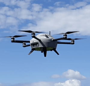
This project will leverage Swiss-based weather drone company Meteomatic’s Meteodrone, which will be operated by GrandSky at their facility. The Meteodrone is designed to fill the hole in between space-based satellites, weather planes and balloons (which operate at higher altitudes in the atmosphere) and ground-based weather observation assets to provide an unprecedented level of observation in real time where much of the weather actually happens.
The Meteodrone will collect information like atmospheric pressure, humidity, wind conditions and ice accumulation in order to get a better view of changing weather conditions, which is increasingly important as the number of serious weather events goes up year-over-year as a response to climate change. Utah-based weather data company Synoptic will handle the collected data and turn it over to the weather service, with the goal of establishing the efficacy of the Meteodrones and inform future weather-observation technology acquisition.
“As the first large scale commercial UAS test park in the nation, we are committed to providing our aircrews with the most accurate weather information possible,” said Tom Swoyer, President of GrandSKY. “We are excited to expand our partnerships to continue researching how UAS enabled weather collection tools can contribute to refined weather awareness across the National Airspace Systems.”
“Synoptic is proud to participate in this cooperative research agreement studying the value of additional lower and middle atmosphere vertical data acquired via Meteodrones to weather forecasting,” said Elizabeth Wilson, Director of Weather Programs at Synoptic. “As the primary data repository for this effort, Synoptic will be storing and delivering these high-quality, low latency data to the National Weather Service in near real time, allowing for a more effective and centralized process for data validation. We’re looking forward to the outcomes and are excited to be at the forefront of these efforts.”
“Meteodrones significantly enhance the accuracy of weather forecasts by filling critical observation gaps in the lower and mid atmospheric boundary layer, offering precise, high-resolution data that revolutionizes our ability to predict severe local weather phenomena. Thus, we are very excited to be part of this forward looking project and to work with great partners on the future of advanced weather forecasting,” says Martin Fengler, CEO and Founder of Meteomatics.
More information on GrandSky is available here.
Miriam McNabb is the Editor-in-Chief of DRONELIFE and CEO of JobForDrones, a professional drone services marketplace, and a fascinated observer of the emerging drone industry and the regulatory environment for drones. Miriam has penned over 3,000 articles focused on the commercial drone space and is an international speaker and recognized figure in the industry. Miriam has a degree from the University of Chicago and over 20 years of experience in high tech sales and marketing for new technologies.
For drone industry consulting or writing, Email Miriam.
TWITTER:@spaldingbarker
Subscribe to DroneLife here.


